With high-quality, precise, and reliable devices Basetime’s Locator One is revolutionising the collection of high-precision geodetic datafor maritime and construction companies, worldwide.
Basetime Locator One offers high-precision GNSS measurements which streamlines processes for large construction companies and maritime corporations with complex surveying tasks.
Powered by Data, Driven by Innovation
Use Locator One to Track Every Movement
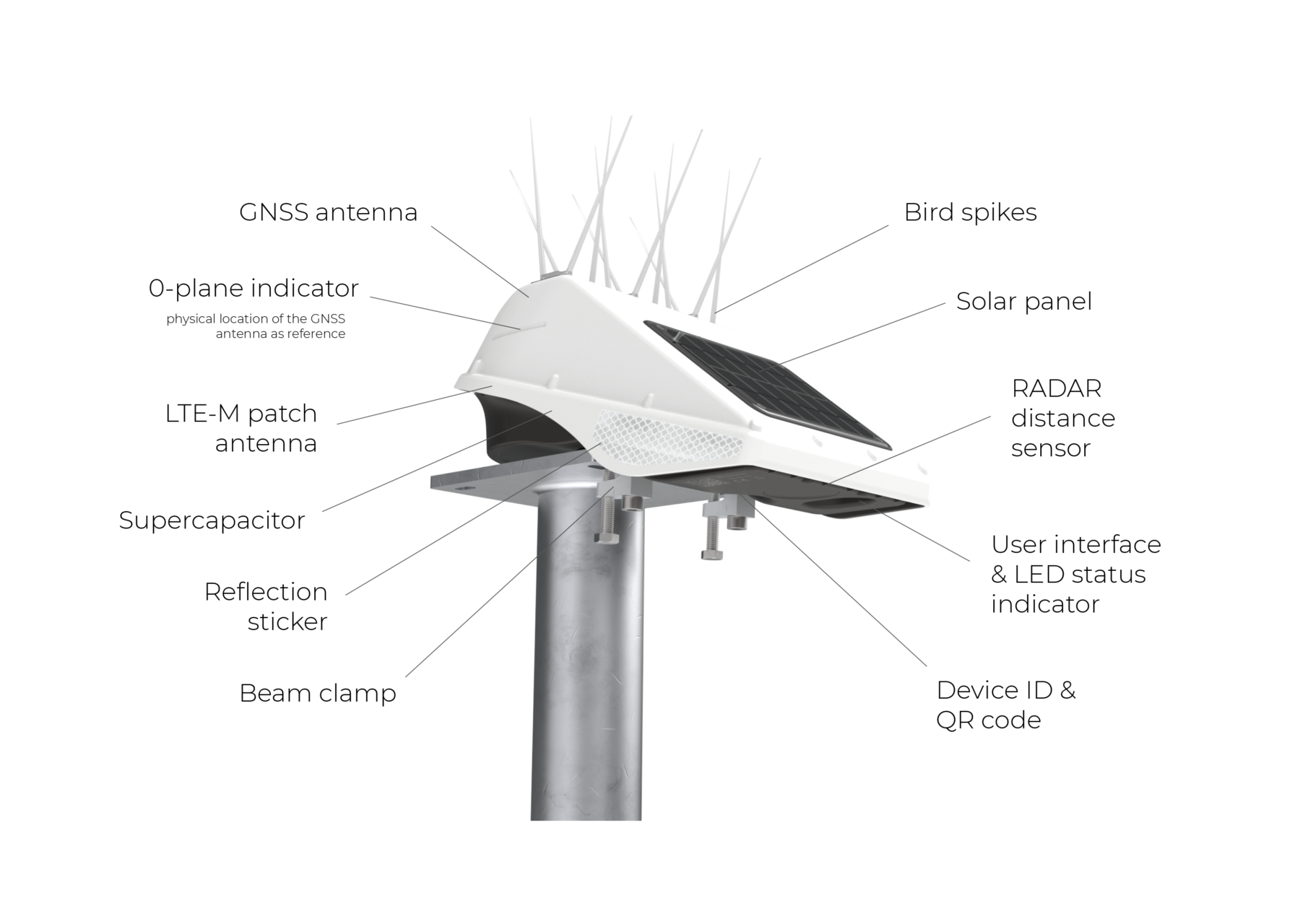
Locator One is a high-precision device that autonomously executes deformation measurements at a set time and place.
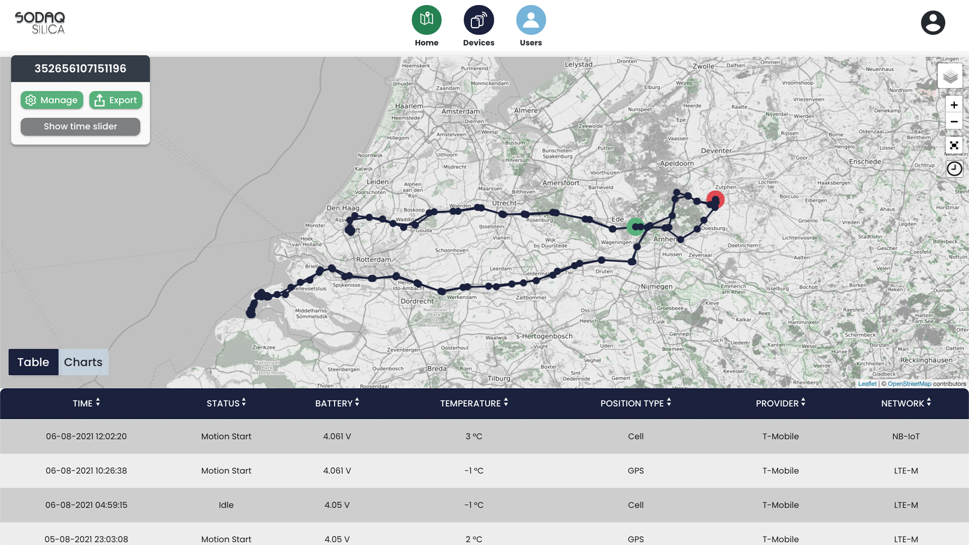
The readings collected by the GNSS and RADAR sensors are computed by subjecting the data to an array of complex calculations, and running it through various algorithms.
From the processed data we are able to extrapolate sub-centimeter precise positioning information, which is then made accessible through the Basetime dashboard or your preferred information system.
Compared to the traditional method of collecting geodetic observations, the delivered data offers numerous advantages.
Measures with the precision of 5 mm along the Z axis and 3 mm along the X-Y axes. An autonomous device guarantees consistent data, high precision and 95% uptime.
Predictability
Collection and calculation of accurate data on predefined timestamps offers prediction of subsidence and settlement allowing for precautionary actions.
Reliability
After installation there is no maintenance required. The ability to function autonomously ensures consistent data for better data analysis.
Safety & Sustainability
Locator One monitors settlement without human interference and eliminates the need for maintenance rides, increasing safety and reducing CO2 emissions during operations.
High-Precision Monitoring Made Easy
How does it work?
InstallationA fleet of Locator One devices are mounted on settlement rods to determine the height of the baseplates, which are positioned at the original ground level.
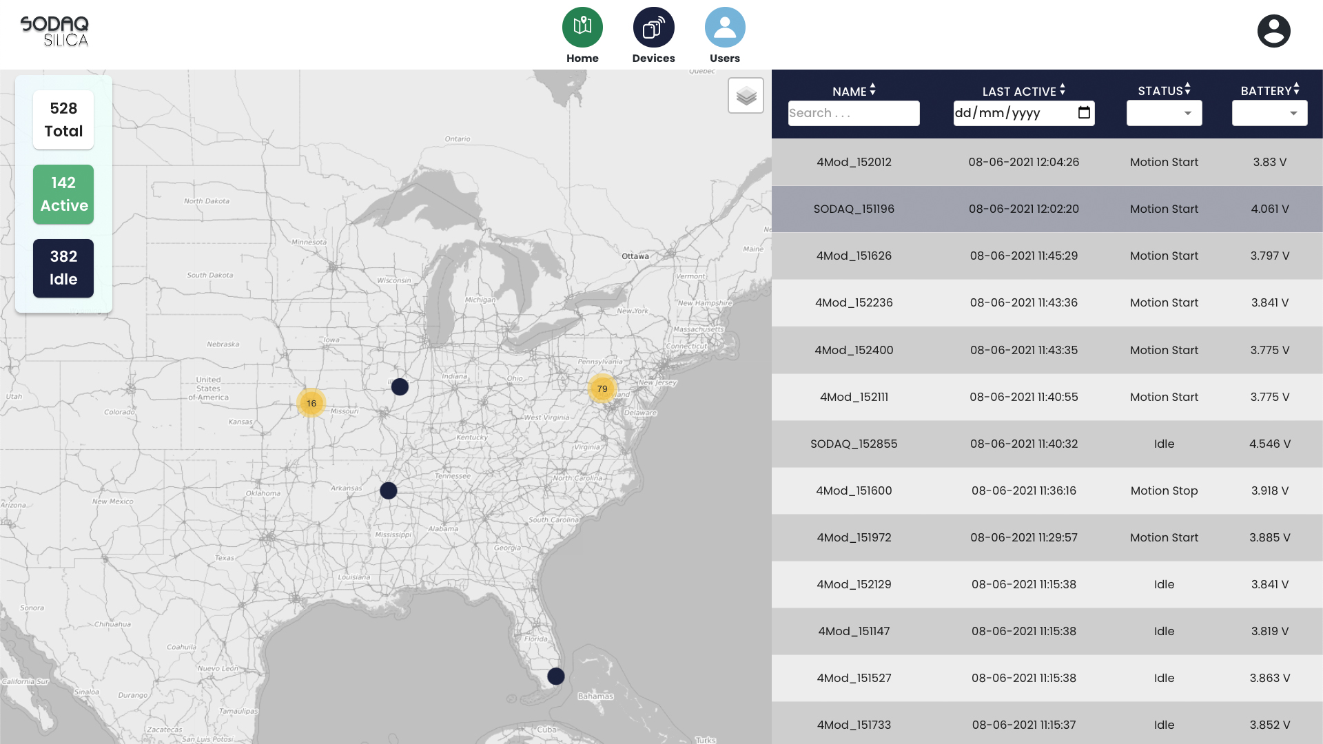
ControlThe devices send their observations and metadata through an IoT network to our cloud. After geodetic adjustments and calculations, the data is delivered.
DashboardResults are displayed on the Basetime dashboard, or preferred environment through an API. In joint consultation, data can be adapted to the contractors working method.
Locator One functions autonomously and is powered by solar energy and a super-capacitor. This ensures functionality even in extreme temperatures of (-20 to +60 Celsius) and significantly minimises the need for maintenance rides. In doing so, it reduces CO2 emissions during operations, increases safety, and minimizes space for human error.
Along with measuring the settlement of layers, Basetime is developing the Locator product range to serve other monitoring purposes such as the movement of bridges, harbour quays and dam walls.
Interested in Locator One? Visit the Basetime website to learn more and get in touch.
A brand new line of asset tracking devices. Built to withstand heavy-duty industrial use. Designed to provide a multitude of readings. Here to bring your assets online and put you in charge.
Locator One is Basetime’s first commercial device, engineered to autonomously monitor your construction grounds. By placing a fleet of devices on settlement rods, we measure the gradual changes in deformation which results in highly accurate data delivered to the Basetime dashboard or a preferred information system.
For who?
Governmental authorities, construction companies, maritime corporations, geodetic and geotechnical engineers that use hundreds of devices for monitoring dikes, dredging grounds, and construction terrains.
What?
Autonomous, precise GNSS-based monitoring system
Backend database, including geodetic and other statistic algorithms, improving the precision of your measurements
Dashboard or API delivering the data directly to you
Tell me more
Basetime’s Locator One is using GNSS and RADAR sensors to monitor and present both the vertical movement of the original ground level, and the height and depth of the added layer of sand. The automated sensors measure the exact position of the settlement rod with a precision of – at most – 5 mm along the Z axis and 3 mm along the X-Y axes. Through these measurements, we are able to provide the detailed information you require on the settlement of the original ground level and the added sand layers.
Reduce risk and loss and boost supply chain performance with real-time visibility. Integrate the SODAQ TRACK Stealth into reusable small containers and boxes moving through your closed loop supply chain, providing you with control over moving assets.
For who?
Organizations with closed-loop supply chains looking to increase transparency and streamline the flow of assets throughout both their own and customer facilities.
What?
Create a connected, transparent supply chain that delivers real-time visibility at every stage.
Receive location, motion or temperature threshold alerts, revealing the exact time and location.
Receive powerful data that enables you to make smarter supply chain decisions. With more control, you can minimize loss and waste, protect content integrity and reduce costs.
Tell me more
Using the TRACK Stealth allows you to monitor the temperature, motion and location of reusable supply chain assets. The Stealth is powered by a rechargeable supercapacitor which allows for an endless number of charging cycles and is able to power the device for up to 3 months.